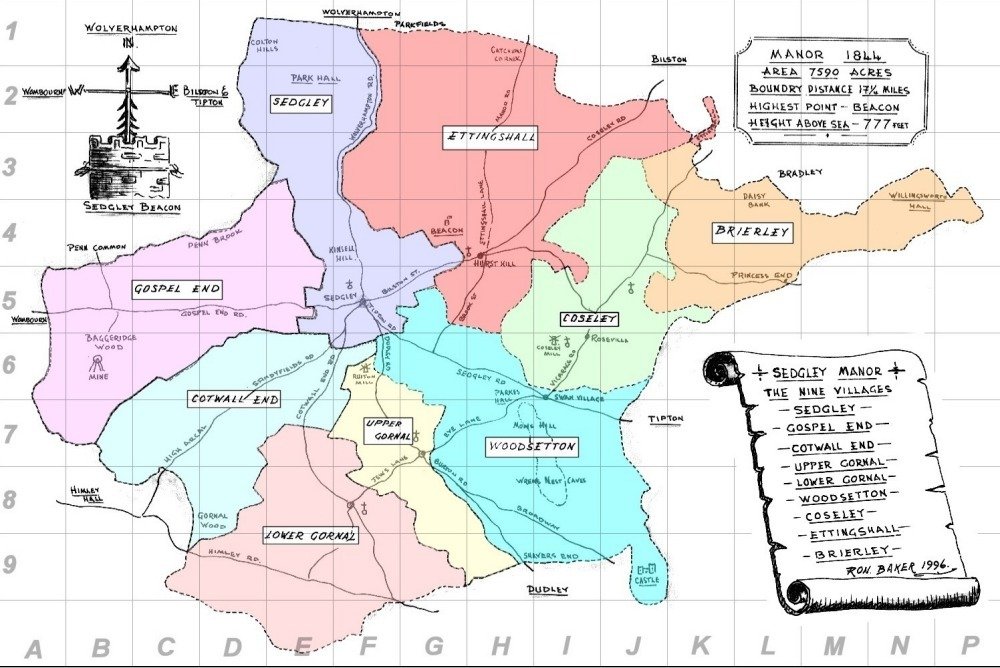

The Manor of Sedgley consisted of nine villages (or Hamlets or Constablewicks), these were
Sedgley
Gospel End (to the west)
Cotwall End (to the southwest)
Upper Gornal (to the south)
Lower Gornal (to the south south west)
Woodsetton (to the southeast)
Coseley (to the west)
Ettingshall (to the north)
Brierley(to the west-northwest) - now called Bradley
There also existed many other "local" names for areas that often didn't appear on any official maps. Some of these are shown below...

| LOCATION | Map Ref |
LOCATION | Mar |
LOCATION | Map Ref |
Baggeridge |
B6 |
Gospel End |
D5 |
Straits, The |
D7 |
Bradley |
|
High Arcal (Cotwall End) |
|
Swan Village |
|
Bull Ring |
|
High Arcal (Woodsetton) |
|
Turl’s Hill |
|
Can Lane |
|
Hurst Hill |
|
Upper Ettingshall (Sodom) |
|
Catchem's Corner |
|
Lanesfield |
|
Wallbrook |
|
Cinder Hill |
|
Mamble Square |
|
Wren’s Nest |
|
Coppice, The |
|
Moden Hill |
|
|
|
Cotwall End |
|
Parkes Hall |
|
|
|
Daisy Bank |
|
Parkfield |
|
|
|
Dibdale (Deepdale) |
|
Princes End |
|
|
|
Dudley Castle |
|
Roseville |
|
|
|
Dudley Union Workhouse |
|
Ruiton |
|
|
|
Ellowes Hall |
|
Sandyfields |
|
|
|
Fullwood’s End |
|
Sedgley Beacon |
|
|
|
Gornal Wood |
|
Shaver’s End |
|
|
|
| Search the whole Sedgley site |